All published articles of this journal are available on ScienceDirect.

Utilization of the Airport Geographic Information Systems (AGIS) to Develop an Accurate Digital Map
Abstract
The adaptation of Airports geographic information system (AGIS) can help them to better manage both air- and ground-side operations; in this paper the section of Erbil international airport site (AIAP) was the case study, representative the AGIS in building infrastructure layers. The results include a multi layers map; each layer has information that contains a comprehensive database. This paper studies the production of a digital map for the study area with multi layers and themes.
INTRODUCTION
Many engineering firms have adopted geographic information system (GIS) as a tool for expansion studies and design reviews. Using spatial but also other quantitative and qualitative data from derived by the local community, such as current roadway or railway access to the airport grounds, airport pavements, neighborhood constraints, and environmental sensitivities, can significantly reduce the time spent in understanding the involved complexities and the particularly for expansions of landlocked facilities in large area.
Wolf et al. (2014) [1] reported that “Airport GIS provides civil engineers with the framework for maintaining and deploying critical data and applications across every aspect of the infrastructure project life cycle including planning and design, data collection and management, spatial analysis, construction, and operations management and maintenance. The provides the tools to assemble intelligent GIS applications and improve a project process by giving engineers, construction contractors, surveyors, and analysts a single data source from which to work. Centrally hosting applications and data makes it easy to manage, organize, and integrate geographic data, including CAD data, from existing databases to visualize, analyze, and make decisions” [2, 3]. In this paper, we tried to make use of the new GIS applications for airports. Integration of digital Photogrammetry implementations into Geographic Information System (GIS) databases presents new possibilities for the end-users. This integration allows photogrammetric data collection in a raster/vector based GIS environment. Also studies the producing of mosaic for our study area, stereo pair and the final form the ArcGIS software was tried to prepare a digital map with multiple layers and themes.
Esri's ArcGIS is a (GIS) software for working with maps and geographic information. It is used for: creating and using maps; compiling geographic data; analyzing mapped information; sharing and discovering geographic information; using maps and geographic information in a range of applications; and managing geographic information in a database [4].
This paper aims to show that GIS can provide the airport management staff with visual information and powerful analysis tool. Mean a while, the spatial information managed by GIS can ensure the accumulation of valid attribute data of an airport. Based on the principle and general implementation process of GIS and the characteristics of airport database management, this paper describes the implementation process of GIS in Arbil International Airport.
Limitation of Orthophotographs
The original aerial negative from, which the orthophotograph is made as a central projection without relief displacement and obscuration of features. This obscuration results in gaps of information that can be gotten only from other sources of information, such as field survey or separate photograph. Also, optical ortho-rectifying devices have a finite width and length slot width that can “rectify” only to an average elevation within that slot. Thus, small objects, such as trees, buildings, etc., are not rectified at all. Normally, only a “smoothed” approximation to the actual terrain is rectified. Digital rectifiers with spot diameters as small as 5 to 25 micrometers can, to a much greater degree, overcome this latter shortcoming.
METHODS (STUDY AREA AND DATA COLLECTION AND CONVERSION)
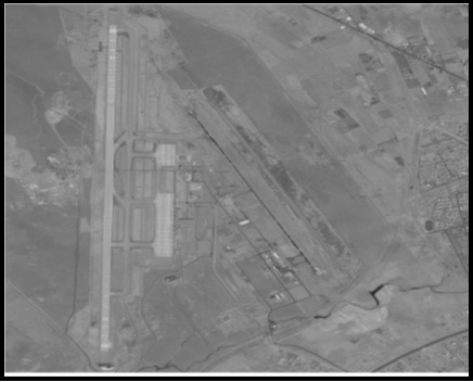
Erbil International Airport, (IATA: EBL, ICAO: ORER), is the main airport of Erbil city in the Kurdistan Region of Iraq, Erbil International Airport is built on the same location where was used as an airfield and military base until 1991. The old airport of Erbil covered 7,000 m2 (75,000 sq ft), and was divided into departure and arrival halls. It had three gates and the runway, which was originally intended for military purposes, was 2,800 m (9,200 ft) long and was provided with an ILS system (Fig. 1) [5].
On July 1st, 2003 the construction of the airport began and on December 15th, 2003 the first aircraft landed at Erbil airport, and flight between Kurdistan Region of Iraq and the neighboring countries started afterwards until 2005, when direct flights from Kurdistan to Europe started by Iraqi Airlines. The warehouse offered cargo space amounting to 4,320 m2 and consisted of an import and an export section. The new airport has the longest runway in the Middle East and the fifth-longest runway in the world after those found at airports in China, Russia, South Africa and America, 4,800 m × 90 m. The new terminal features modern amenities such as duty-free shops and currency exchange offices. The terminal features CIP areas for visiting business jets, and there is a VIP terminal for visiting dignitaries and diplomats [5].
Each of analogue and digital data is gathered for the study area including: A digital base map for Erbil airport site and the eight digital aerial photos. The images, which are illustrated in Fig. (2), used in this study captured from space by the military have the following characteristics:
- A focal length of (152.16 mm),
- Flying height (456.48 m),
- The completion of this work needs to eight aerial photos of the area. The mosaics have been found that the site of Erbil International Airport.
- The entire airline has four images so that there is a common area shows each image of the photo that followed in the line of flight, one is called the forward overlap or overlap the front and the amount (60%). And
- An overlap (side lap) or (End Lap) here under (30%) were converted this image to a digital format (Digital form) using (Scanner).
The final result of matching the mosaic of eight digital Arial photos of Erbil airport site is corrected by using ERDAS LPS (V 9.2) software.
RESULTS (ANALYTICAL CLOSE RANGE PHOTOGRAMMETRY)
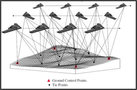
Photogrammetry and GIS are becoming closely interrelated. In this paper, data from GIS databases are used as control information for automatic orientation of aerial image, changes and discrepancies between recent imagery and existing GIS databases are automatically highlighted for change detection and updating purposes. So data taken from digital close range photogrammetry can be analyzed into GIS program and provided more simple information and easily used.
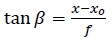
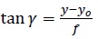
The collinearity equation is the most fundamental equation in spatial positioning. It can be used for solving any spatial positioning problem associated with directional data acquisition systems .The six elements of exterior orientation can be determined if the interior orientation is known and the image and object space coordinates of at least three points are given. This operation is analogous to resection in geodetic surveying, where the coordinates of the instrument station are determined by sighting points with known coordinates. Therefore, this operation is referred to as space resection [6].
The collinearity equation, for the present case study, can accommodate angles as observations since:
 |
(1) |
and
 |
(2) |
Where β and γ are angles formed by a ray and the optical axis of the camera in the xz and yz planes respectively.The interior orientation elements be treated as unknowns and so called additional parameters can be included, which model various distortions affecting the imaging process. In this form, the collinearity equation is used for sensor calibration [7].
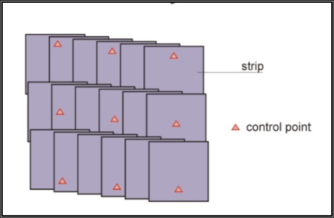
The process is named bundle adjustment because of many light rays that pass through each lens position constituting a bundle of rays. The bundles from all photos are adjusted simultaneously so that corresponding light rays intersect at positions of the target points. The mathematical model of Bundle Adjustment is the collinearity equations [1]. The strip of block aerial photo showed in Figs. (3 and 4) below:
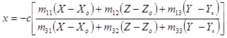
The form of collinearity equations in close range Photogrammetry is as follows [3]:
 |
(3) |
 |
(4) |
where:
x, y: the image point coordinates.
X, Y, Z: the object point coordinates.
Xo, Yo, Zo: the coordinates of the exposure station in the object space system.
c: the camera focal length.
m's: the elements of rotation matrix.
Since the collinearity equations are not linear, they are linearized by applying the first order terms of Taylor's series at a set of initial approximations. After linearization the observation equations can be expressed in the following matrix form:
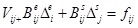 |
(5) |
Where
 |
 |
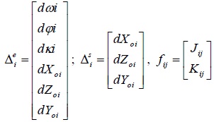 |
In some cases, there an additional equations to the mathematical model. These equations can be divided into two groups, the first group represent the exterior orientation parameters observation equations, to drive these equations let (ωioo, φioo, κioo, Xoioo, Yoioo and Zoioo) be the measured values of the exterior orientation of photograph i and let Vωi, Vφi, Vκi, VXoi, VYoi, and VZOI be their corresponding unknown residuals [5]. Thus the true values of these six orientation parameters may be expressed as follows:
 |
(6) |
 |
(7) |
 |
(8) |
 |
(9) |
 |
(10) |
 |
(11) |
Although all six parameters are included in the above set of equations, observation equations need only be written for the parameters that actually have measured values. Equation (3.16) may be represented by a single matrix equation as:
 |
(12) |
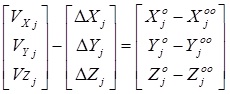
Observation equations for the ground coordinates can be derived in exactly the same manner as for the exterior orientation parameters let Xjoo, Yjoo and Zjoo, be the ground coordinates of a point j determined previously from ground surveys, let VXj, VYj and VZj respectively such that the ground coordinates of point j can b expressed as follows (Salem, 2009):
 |
(13) |
 |
(14) |
 |
(15) |
Furthermore, it can be defined as:
 |
(16) |
 |
(17) |
 |
(18) |
Therefore,
 |
(19) |
 |
(20) |
 |
(21) |
Rearranging terms and putting the equations into matrix form yields
 |
(22) |
These are the observation equations for the known (or measured) ground coordinates of point j. They may be simply written as a single matrix equation as follows:
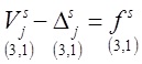 |
(23) |
Building the Themes of the Digital Map
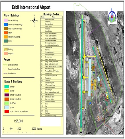
After the production of mosaic for that study area, stereo pair of the final form the ArcGIS software was used to prepare a digital map with multi layers and themes. The themes, which formed, were: (buildings theme, runway theme, taxiway theme, runway and taxiway shoulder theme, blast pads theme, public and service access road theme, car parks, helipad, fences theme, aprons theme).
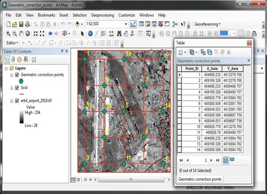
The next step comprised the completion of the drawing layers have been producing digital map in its final form with scale of 1:25,000. This scale is appropriated to the scale of digital aerial photographs that was used in the production, which in turn was to be used to produce the digital map; fourteen points, which are listed in Table 1, were selected as check points and they were measured by using total station (Topcon ES-107) instrument to compute the resulted accuracy Root Mean Square Error (RMSE) by using the following equations, which was presented previously in chapter two of this paper:
| Remark | X (Northing) | Y (Easting) |
|---|---|---|
| 1 | 404688.232000 | 4013278.768000 |
| 2 | 409169.326000 | 4013278.768000 |
| 3 | 404688.232000 | 4008490.757000 |
| 4 | 409169.326000 | 4008490.757000 |
| 5 | 406928.779000 | 4010884.762000 |
| 6 | 405808.506000 | 4012081.765000 |
| 7 | 408049.053000 | 4012081.765000 |
| 8 | 405808.506000 | 4009687.759000 |
| 9 | 408049.053000 | 4009687.759000 |
| 10 | 406928.779000 | 4013278.768000 |
| 11 | 406928.780000 | 4008490.757000 |
| 12 | 404688.232000 | 4010884.762000 |
| 13 | 409169.326000 | 4010884.762000 |
| 14 | 405808.506000 | 4010884.762000 |
 |
(24) |
where:
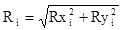
Ri: The RMSE for check point (i).
Rxi: The X residual for check point (i), (the distance between the source and the transformed coordinates in x direction).
Ryi: The Y residual for check point (i), (the distance between the source and the transformed coordinates in y direction).
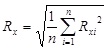
Depending upon the residuals, the RMSE in X coordinate, the RMSE in Y coordinate, and the total RMSE can be computed from the following equations [9]:
 |
(25) |
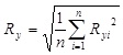 |
(26) |
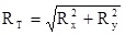 |
(27) |
where:
RT: total Root Mean Square Error (RMSE).
n: number of check points.
The resulted accuracy (Root Mean Square Error (RMSE)) computed by using a spatial equation (27) as described above was (50) cm. Fig. (5) shows Erbil International Airport ArcGIS themes.
DISCUSSION (DEVELOPING THE FINAL DIGITAL MAPS)
After producing the resulting photo for our study area, stereo pair of the final form ArcGIS software was utilized preparing a digital map of multiple layers and themes. Themes, that are configured, are: (buildings theme, runway theme, taxiway theme, runway and taxiway shoulder theme, blast pads theme, public and service access road theme, car parks, helipad, fences theme, aprons theme). Two final maps were developed, two first images as shown in Figs. (6 and 7) include (EIA total map which represented in nine themes, scale bar and compass direction).
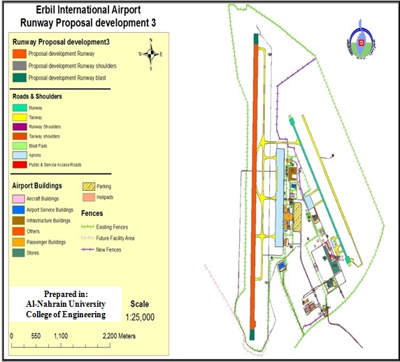
These two maps are produced according to the rules of drawing and production of maps and utilized from the Engineering Unit in Erbil International Airport.
CONCLUSION
From the results obtained in this paper, the following conclusions can be extracted:
- Most airports in Iraq still rely on the use of AutoCAD in mapping, while there is a lot of data and information that the reservation is lost with the passage of time.
- To organize the spatial entities effectively, several layers are set according to the characteristics of spatial entities. These layers are developed depending on the using of the orthophoto of Erbil Airport, which has been corrected analytically and then considered as an input for the AGIS.
- The AGIS digital map is essential for different applications including airport monitoring and management, pavement analysis, site development, noise pollution determination, and several navigational operations.
- This study has proven the effectivness of integration photogrammetry and geographic information system (GIS) in digital map production. It has shown that the integration of photogrammetry and GIS method is able to capture digital data much faster and accuratly. This technique increases cost-effective productivivity and provides server with a very useful tool for planing purpose .
- The production of the map through Airport geographic information system (AGIS) software is easy and effective way, and shorten the time and when compeared with traditional production methods used in photogrammetry using stereoplotter equipment, one of the very expensive equipment and it requires time and effort as big.
- Simultaneous bundle adjustment using ERDAS IMAGIN software has sufficient accuracy level for large scale mapping. Automatic tie point generation using exterior orientation parameters produced by total station made dense and high accurate tie points and the block geometry were noticed to be better.
- The resulted accuracy ((Root Mean Square Error (RMSE)) computed by using a spatial equation (27) as described above was (50) cm, which is considered a good resolution for this kind of application.
CONFLICT OF INTEREST
The author confirms that this article content has no conflict of interest.
ACKNOWLEDGEMENTS
Declared none.

