All published articles of this journal are available on ScienceDirect.

Research on Solutions for Developing the Road System in Dien Bien Province, Vietnam
Abstract
Introduction
Dien Bien province is situated in the Northwest region of Vietnam. It plays a significant role in national security, both within the region and nationwide. The province benefits from historical sites, scenic landscapes, and significant potential for agricultural and forestry development. These advantages provide favorable conditions for the growth of services, tourism, and agroforestry processing industries.
Methods
However, the road transport infrastructure in Dien Bien province remains inadequately developed, limiting connectivity and posing a significant barrier to the socio-economic development of the locality, as well as neighboring regions. In recent years, some plans for road transport infrastructure have been implemented, producing measurable outcomes. Nevertheless, the development of road transport in Dien Bien continues to face many challenges and obstacles.
Results
The paper analyzes the development of the road transport system in Dien Bien province during the period from 2016 to 2024. It further identifies key challenges and limitations while proposing several strategic solutions aimed at enhancing road infrastructure.
Discussion
The development of the road system in Dien Bien province faces major challenges such as limited investment, mountainous terrain, and slow adoption of digital technologies. Despite the province having strengths in cross-border connectivity, tourism, and land resources, it also struggles with low road density and disaster risks. Thus, solutions should focus on mobilizing diverse investments, applying modern technologies, and promoting sustainable, climate-resilient road development.
Conclusion
Enhancing the transport network will significantly contribute to the province’s sustainable socio-economic development in the future.
1. INTRODUCTION
1.1. Characteristics of Dien Bien Province’s Road System
Dien Bien province (Fig. 1), a mountainous province located in the Northwest border area of Vietnam, holds a very important position for national security. Dien Bien has an area of 9.539,93 square kilometers and shares borders with Lai Chau and Son La. It shares a 455.57-kilometer boundary with Laos and China and is approximately 504 kilometers from Ha Noi. The province has some important international border gates with China and Laos, such as Tay Trang and A Pa Chai. Moreover, the province also has other entry points, such as Huoi Puoc, Si Pa Phin, and Na Bung [1]. These facilitate international trade and enhance Dien Bien’s potential as a transit hub on the Northern Trans-Asian road connecting Northwest Vietnam with Laos and Southwest China. The province boasts rich tourism resources, including natural landscapes and cultural heritage sites, with the Dien Bien Phu battlefield as a central symbol of historical resilience. Other notable attractions include Ban Phu Castle and Muong Thanh Bridge. Dien Bien is home to 19 ethnic groups, including the Thai, Mong, Kho Mu, Dao, Lao, Kinh, Ha Nhi, Tay, Nung, Hoa [1]. Each ethnic group has distinct characteristics in terms of language, customs, and culture. Together, they create a diverse culture in Dien Bien province for tourism development. With a population of around 656.706 (According to the Dien Bien Province Statistical Yearbook in 2024), Dien Bien has a low population density of 68.84 people per square kilometer, highlighting its mountainous and sparsely populated character [1].
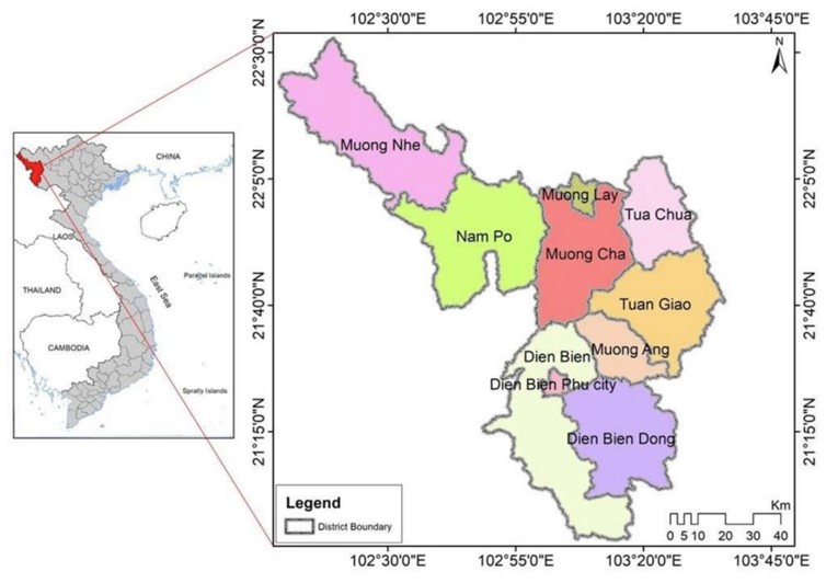
Location of Dien Bien province on the map of Vietnam. (Source: The author uses GIS to establish the coordinates of the area).
The province has abundant water resources and favorable climatic conditions for agriculture, forestry, and related processing industries, attracting increasing investment in these sectors. Dien Bien province plays an important role in promoting the development of the economy and society in the Northwestern region and Vietnam as a whole. Several plans for road network development in Dien Bien have been carried out, and the province's road infrastructure is gradually being improved and upgraded. Despite these efforts, the development rate is progressing slowly and lacks coordination, presenting significant challenges for connectivity and the transportation of goods, which are slow and costly.
Developing the road transportation system plays an important role in promoting the key industries of Dien Bien province, including the energy industry, the agricultural product processing industry, and the construction materials production. These industries share the common characteristics of requiring large and stable transport volumes, effective regional connectivity, and quick access to consumer markets. Among them, investing in favorable transportation infrastructure helps promote the development of the energy industry, facilitating the transportation of equipment and materials for hydropower and energy projects, and contributing to accelerating the construction and operation of power plants in remote areas. In addition, the development of roads facilitates the connection from raw material areas to factories and consumption markets, helping to develop the local agricultural processing industry. At the same time, since the brick and stone production facilities in Dien Bien province are mainly located in mountainous districts, the development of the road system will contribute to the growth of the construction materials industry, facilitating the transportation of materials to major construction projects in the province and neighboring areas efficiently and quickly. It can be seen that road development is not only a transportation goal but also an important lever to promote industrialization, especially with the three key sectors that have clear strengths in Dien Bien Province. The synchronization between transportation infrastructure investment and industrial planning will help the province enhance its competitiveness, fully exploit local potential, and move towards effective integration with both domestic and international markets.
This paper examines the development of Dien Bien’s road system from 2016 to 2024, identifies existing limitations, and proposes solutions to enhance transportation infrastructure for sustainable socio-economic growth.
1.2. Literature Reviews
The road transportation system holds a vital role, integrated into the national logistics and transport framework, playing a role in enhancing socio-economic growth, ensuring national defense and security, and improving people's living standards. Although Vietnam’s road system has improved, its quality still lags behind development needs [2].
In several studies, transportation infrastructure is considered a key factor in development and economic growth. It serves as the main driver of economic advancement at all geographical levels, especially in regional and local contexts, by facilitating the movement of goods and services [3-5]. Roads enable the mobility of goods and people, promote trade, and support social cohesion [6, 7]. In developed nations, infrastructure advancements have reduced costs and fostered growth, while low- and middle-income countries still face significant infrastructure gaps [8]. As a result, innovative financing mechanisms such as public-private partnerships (PPPs) have become increasingly common [9].
In Vietnam, studies on transport infrastructure emphasize its impact on regional planning, public investment, and project outcomes [10-12]. One such policy is Decision No.1454/QĐ-TTg, dated September 1, 2021, which approves the Road Network Planning for the 2021-2030 period with a vision towards 2050. This Decision outlines comprehensive objectives for sustainable and integrated road system development. The key objectives include: (i) developing integrated transportation infrastructure to enhance the quality and service capacity of the road network; (ii) strengthening effective connectivity between regions and localities to reduce development disparities; (iii) meeting the demand for freight and passenger transport; (iv) building a sustainable transportation system that protects the environment and supports the green growth strategy; and (v) attracting investment from various sources, including both private and foreign entities, to develop transportation infrastructure [13].
However, poor planning can lead to cost overruns, corruption, and minimal socio-economic return [14]. Thus, infrastructure planning must be context-specific and strategically evaluated. While existing studies provide national-level analyses, few address the challenges of remote mountainous provinces like Dien Bien. This paper addresses that gap by focusing on Dien Bien’s unique conditions and development needs.
2. MATERIALS AND METHOD
This paper examines the development of road transport in Dien Bien Province, Vietnam. By applying analytical and synthetic methods and data processing tools, the paper aims to examine the current situation and identify barriers in road system development in the province from 2016 to 2024. The analysis is grounded in secondary data from credible sources, including official reports, academic research, books, and statistical publications, assessed through a SWOT analysis to propose effective solutions.
The research process is illustrated in Fig. (2).
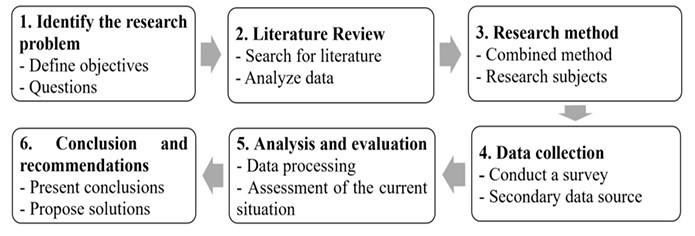
Stages of the research implementation process.
2.1. Step 1- Identifying the Research Problem
Analyze the current status of transportation development in Dien Bien province and propose appropriate solutions. Then ask questions about the difficulties and challenges in developing transportation in Dien Bien? What are the potential solutions?
2.2. Step 2 - Literature Review
Collect domestic and international studies on transportation infrastructure development. Then the paper analyzes experiences and research gaps related to Dien Bien province.
2.3. Step 3 - Research Methodology
Employ a combination of research methods. And define the research subjects as road transport routes in Dien Bien province.
2.4. Step 4. - Data Collection
Collect secondary data from several sources such as legal records, agency reports, and provincial planning documents.
3. RESULTS
Dien Bien province has prioritized strategic planning in road transportation to develop a synchronized road system, as shown in Fig. (3). This effort not only fulfills economic and social advancement tasks but also ensures national defense and security.
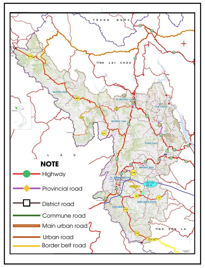
Traffic network planning map for Dien Bien province during 2021–2030, looking ahead to 2050.
The province benefits from favorable land and climate for agriculture, tourism, and processing industries. Strategic transport planning plays a vital role in leveraging these advantages [15]. In recent years, authorities have focused on creating a synchronized transport network, enhancing accessibility, and economic integration. The province’s efforts are guided by national and local decisions such as Decision No.12/QĐ-TTg and Resolution No.16/NQ-TU [16, 17].
As of early 2024, Dien Bien's road network spans 9,212.2 kilometers, including six national highways with a combined length of about 745 kilometers [19]. Notably, 100% of communes have road access, with 95.3% accessible year-round [20]. Key projects include upgrades to National Highways 279 and 12 and the Si Pa Phin – Muong Nhe route, promoting connectivity and tourism.
The Son La – Dien Bien – Tay Trang Expressway (Phase 1), implemented under a PPP model, illustrates government commitment. Nevertheless, challenges remain in terms of investment scale, technical standards, and long-term maintenance.
The implementation of the Provincial Planning (2021–2030, vision to 2050) under Decision No.109/QĐ-TTg (2024) requires prioritized resource allocation to develop resilient infrastructure supporting long-term growth.
In addition, this paper analyzes road types and standards to evaluate the completeness and performance of Dien Bien’s multi-tiered road system, and to identify solutions to strengthen planning, investment, and infrastructure efficiency.
3.1. The Current Status of Road Network Development in Dien Bien Province
Dien Bien province has a road network totaling 9,212.20 kilometers, including national highways, provincial and district roads, urban and commune roads, border patrol roads, and village roads [18, 20]. The road classification by pavement layer in the province is summarized in Table 1.
| STT | Type of Pavement Layer | Unit | Quantities | Percentages |
|---|---|---|---|---|
| 1 | Cement concrete pavement | Km | 2 945.20 | 31.97% |
| 2 | Asphalt pavement | Km | 507.40 | 5.51% |
| 3 | Asphalt macadam pavement | Km | 1 371.70 | 14.89% |
| 4 | Aggregate pavement | Km | 1 093.20 | 11.87% |
| 5 | Stabilized earth road pavement | Km | 3 294.70 | 35.76% |
| - | Total | Km | 9 212.20 | 100% |
Table 1 illustrates that stabilized earth pavement (35.76%) and cement concrete pavement (31.97%) are the main surface types, while asphalt covers only 5.51%.
The average road density is 96.3 km per 100 km2. Although Dien Bien has six national highways totaling 745 km, investment remains uneven, resulting in generally poor surface quality [19]. In Fig. (4), the road types in Dien Bien province consist of national highways, provincial routes, district thoroughfares, urban streets, community roads, village pathways, border patrol trails, and intra-field pathways [20]. Connectivity with neighboring provinces is limited due to the absence of expressways. National roads account for nearly 8%, and provincial roads about 6% of the total network.
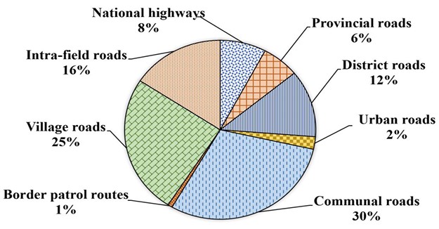
Classification of different road types in Dien Bien province [20].
3.2. Current Status of National Highways under Central Management
Managed by the Central Government, national highways act as inter-regional routes that connect Dien Bien province to major economic zones and major transportation hubs in the region.
The system of national roads in Dien Bien province comprises six routes with a total length of 745 kilometers (Fig. 5). It includes 68 kilometers of cement concrete pavement, 336 kilometers of asphalt concrete pavement, and 341 kilometers of gravel pavement. Of this total, the Dien Bien Department of Transport, which has now been merged into the Dien Bien Department of Construction, has been entrusted by the Vietnam Road Administration to manage 620.9 kilometers [20]. The inter-regional transportation system connects Dien Bien province to neighboring provinces and cities through National highways 12, 6, 279, 279B, 279C, and 4H. The details are as follows:
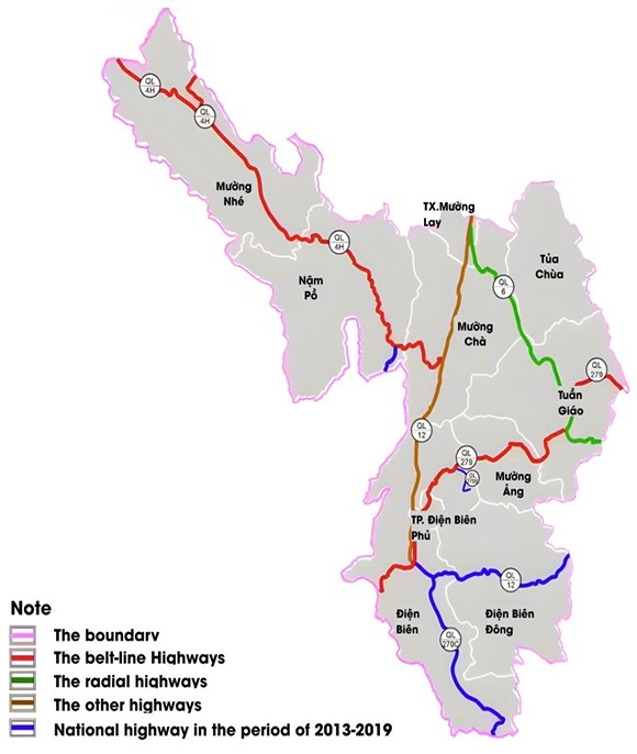
Current condition of the national highway system in Dien Bien province. Source: construction department of Dien Bien province.
National highway 12: This route traverses Dien Bien province, with an overall length of 188.63 kilometers (class IV mountainous road). Its extension measures 84.03 kilometers and has a standard class VI mountainous road.
National highway 6: This route connects the districts of Tuan Giao, Tua Chua, Muong Cha, and Muong Lay, with a total length of 112 kilometers, consisting of 95 kilometers classified as a class VI and 17 kilometers as a class IV mountainous road.
National Highway 279: This route runs through Tuan Giao district, Muong Ang district, Dien Bien Phu city, and Dien Bien district before reaching the Tay Trang International border gate. It covers 130.3 kilometers, classified as a class IV rural road network. Additionally, the segment of National route 279B is 11.5 kilometers (class VI mountainous road), and National highway 279C is 68.2 kilometers (class V mountainous road).
National Highway 4H: This route runs through Muong Cha, Nam Po, and Muong Nhe districts, with a total length of 190.2 kilometers (class V mountainous road). It includes two branches of class VI mountainous road: National route 4H1 with 13.2 kilometers, and National route 4H2, with 37 kilometers.
Despite development efforts, mountainous terrain and limited road density hinder connectivity.
3.3. Current Status of Roadways Administered by the Local Government
The locally managed roads represent internal transportation routes. The types of roads include provincial roads, district roads, urban roads, commune roads, and village roads. Of these, the provincial road system plays a key internal routes connecting various localities, with some routes functioning as radial axes and ring roads. Currently, the provincial road system in Dien Bien includes six routes, which are ĐT139, ĐT140, ĐT141, ĐT142, ĐT143, and ĐT150, with a total length of 140 kilometers. Additionally, there are 17 routes managed by the districts, about 467.8 kilometers. Although the provincial road system in Dien Bien province has not received significant investment, it generally meets the basic transportation and travel needs of the local population.
In recent years, the rural transport infrastructure of the province has developed under the motto “The State and the People working together”, despite facing numerous challenges related to limited funding and complex weather conditions (Figs. 6 and 7). The rural road system spans 7,927.58 km, with 2,509.9 km paved, 905.7 km gravel, and 4,511.9 km unpaved. All 129 communes are connected by roads; 123 (95.3%) are accessible year-round by car, while 6 communes are seasonally accessible [20].
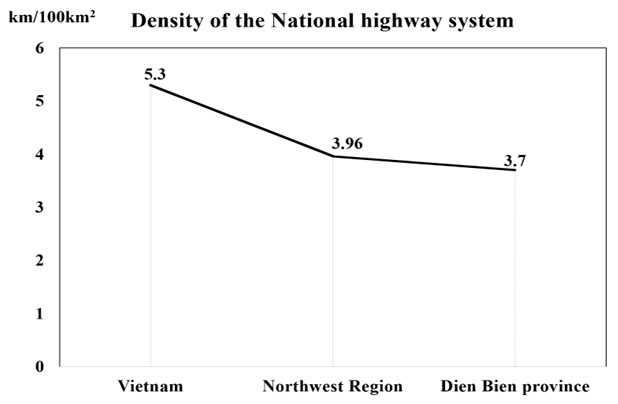
Comparison of national highway network density in Dien Bien province, the Northwest region, and nationwide Source: Construction Department of Dien Bien Province.
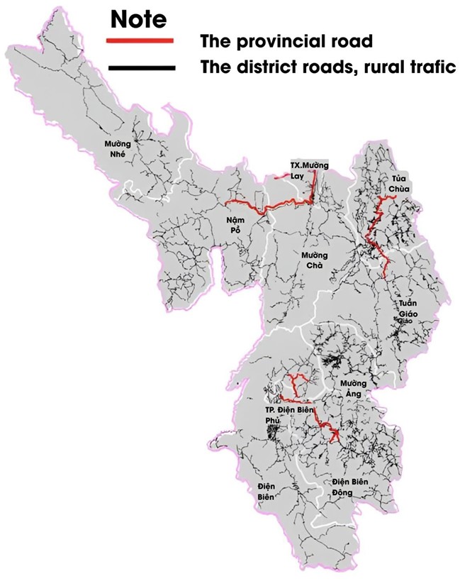
Current status of the provincial road system in Dien Bien province. Source: Construction Department of Dien Bien Province.
3.4. Current Condition of Road Surface Structures
As reported by the Dien Bien Department of Transport, many roads fail to meet national technical standards. Most are class IV or VI, with low-durability surfaces (asphalt, macadam, gravel, stabilized earth). This poses challenges, especially in remote areas and during the rainy season, hindering socio-economic development. Fig. (8) presents the percentage distribution of different types of road surface structures in the province.
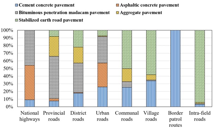
Percentage distribution of road surface types in Dien Bien province [20].
4. DISCUSSION
4.1. Challenges and Limitations
The development of the road transportation system in Dien Bien province faces several key challenges. Including:
First and foremost is the severe shortage of investment capital, which has led to fragmented and unsynchronized road construction and upgrading. As a result, the unsynchronized investment in the construction, upgrading, and renovation of road networks. Consequently, both inter-regional and intra-regional connectivity remain significantly constrained. To develop the road transportation system, the province requires an estimated investment of tens of trillions of Vietnamese dong. Specifically, the total capital demand for the transportation development plan is estimated at VND 51.696 trillion, of which VND 28.483 trillion is allocated for the period from 2020 to 2030 [18]. Delays in capital disbursement have caused numerous road projects to remain unfinished, compromising safety and interrupting project continuity.
Second, the province's mountainous terrain and extreme weather conditions significantly complicate construction and increase costs. Most road infrastructure projects mainly pass through high mountainous regions with complicated geological structures. Moreover, due to unpredictable weather conditions, heavy and prolonged rainfall frequently occurs, affecting construction directly and requiring substantial technical design solutions. Additionally, construction policies are subject to frequent changes, and fluctuations in raw material prices cause construction delays in project timelines.
Third, the application of information technology (IT) in the transport sector is limited, particularly in remote areas. Dien Bien is a mountainous province that faces numerous socio-economic challenges due to its rugged terrain, low population density, and limited financial resources. These factors pose major barriers to the advancement and application of information technology in the transportation sector. As a result, the adoption and application of IT in the development and management of the road transport system face several difficulties. Four key challenges include: (i) Weak IT infrastructure; (ii) Insufficient IT system and skilled personnel; (iii) Limited budget and policy support; and (iv) Low public awareness of smart transport solutions.
4.2. SWOT (Strengths – Weaknesses – Opportunities - Threats) Analysis for Limitations and Challenges
Based on the collected data regarding the current status of road transportation system development, the paper conducts a SWOT (Strengths – Weaknesses – Opportunities - Threats) analysis as shown in Table 2 to identify strengths and weaknesses, opportunities, and threats for the progress in the road transportation infrastructure of Dien Bien province.
| Strengths | Weaknesses |
|---|---|
| (1) International connectivity: Dien Bien province has favorable conditions for road exchanges with China and Laos through open routes and border gates, such as A Pa Chai (China), Tay Trang International border gate (Phongsali, Laos), and the Huoi Puoc Border Gate (Luang Prabang, Laos). | (1) Difficult terrain: Mountainous topography increases construction costs and limits road expansion. |
| (2) Tourism resources: The rich cultural and historical values help develop inter-regional and intra-provincial road transportation. | (2) Limited and unsynchronized infrastructure: Many roads remain underdeveloped or unfinished due to delayed disbursement, limited investment capital, and weak technical standards. |
| (3) Favorable land fund: The extensive land resources allow for the development of road transportation without incurring significant costs for land compensation and clearance. | (3) Low road density: The provincial road density averages only 96.3 kilometers per 100 square kilometers, lower than that of other provinces in the Northwest region and across the country. |
| (4) Airport: It is the only province among the six northwestern border provinces with an airport, capable of accommodating 500,000 passengers annually. | (4) Low standard roads: A large number of roads remain at low technical grades (Class IV, Class VI), with poor surface materials. |
| - | (5) Vulnerability to natural disasters: This province is heavily affected by climate change, frequently causing landslides, floods, and road erosion, posing significant challenges in maintaining road infrastructure. |
| Opportunities | Threats |
| (1) Economic corridor connectivity: There is potential for connection with multiple economic development corridors, expanding trade opportunities. | (1) Climate change: The impacts of climate change lead to landslides and dangers for transport vehicles and all categories of road users. |
| (2) Integration of transport modes: Harmonious integration of various transport modes will enhance road transport capacity. | (2) Low road classification: Provincial and district roads remain in poor condition and are prone to damage from heavy vehicle loads. |
| (3) Modern technology: The development of technology and scientific techniques supports the construction of road transportation. | (3) Low level of industrial development: The industrial sector is not sufficiently developed to support the upgrading of roadways. |
| (4) Formation of service centers: There is a significant opportunity to develop a road transport service center in the region. | (4) Forest resource protection: The expansion of district and commune roads in forested and protected areas may pose risks to forest conservation efforts, especially in regions with designated protection zones. |
| (5) Economic development: The transportation routes to the A Pa Chải open route have great potential for economic development, especially in the fields of commerce and tourism. | (5) Difficulties in collaboration: Many small production facilities and businesses, along with impoverished residents, make it challenging to implement transportation projects. |
| (6) Climate change adaptation funding: Opportunities to access international and national climate resilience programs can support infrastructure strengthening in vulnerable areas. | (6) Fiscal dependency: The province heavily relies on central government funding and lacks mechanisms for mobilizing private investment, which threatens long-term transport development if public funding decreases. |
4.3. Several Solutions to Facilitate the Development of the Road Transport System in Dien Bien Province
Dien Bien is regarded as one of the least economically developed provinces in Vietnam and continues to encounter numerous challenges in its socio-economic development. Based on the economic development index, the province is ranked as the fifth lowest in Vietnam. Therefore, to promote socio-economic development, the province needs to implement key solutions aimed at developing the road transport system, thereby enhancing economic and cultural connectivity with both the Northwestern region and the broader Vietnamese territory.
The first solution is necessary to strengthen the cooperation between various state agencies, especially in the planning and development of transport policies, within the framework of a strategy prioritizing infrastructure growth in the provincial plan. It has been stated: “Transport infrastructure drives development, enhances connectivity, and generates new and distinctive value”. Based on the results of quantitative analysis by the regression model, the estimated road transport infrastructure development index of Dien Bien province is 24.53. This shows the simultaneous impact of several key factors, such as road density, the ratio of paved roads, the ability of cars to travel year-round, investment capital, and the number of national highways. Especially, the negative impact of the average distance to the provincial centre highlights the necessity of improving accessibility in deep and remote areas. Therefore, infrastructure solutions need to aim at minimizing this spatial disparity while simultaneously enhancing the overall efficiency of the system. This includes projects for the development of inter-regional transportation infrastructure, new highway construction, and national and provincial road upgrades. Several principal projects should be prioritized, including:
- Enhancing the highway network that connects Tuan Giao, Muong Ang, Dien Bien Dong, and Dien Bien Phu City, as well as the Tay Trang border gate to Son La. The construction of the Dien Bien – Son La road is proposed for the pre-2030 period, with a minimum Class III specification, two lanes, aimed at boosting socio-economic development and setting the stage for the future expressway.
- Expanding the system of roads at both national and provincial levels to improve connections with expressways, urban centers, production areas, and border gates.
- Proposing the construction of an expressway connecting to Lai Chau province to strengthen regional connectivity, along with a bridge in the Tua Chua area to enhance transport connections with Lai Chau.
The second solution is crucial to develop a road transport plan connecting China and Laos, aiming to access neighboring markets, promote bilateral trade, and enhance logistics efficiency. Simultaneously, this strategy would enhance the province's regional competitiveness and attract greater investment. A plan should be developed to update and expand the national highway system, ensuring expressway connections are completed on schedule, thereby improving inter-regional connectivity with localities after 2030. The province should prioritize the target that, by 2030, the national highway system passing through the province to be upgraded, basically meeting the standard of class IV roads, and provincial roads will be gradually improved and upgraded to satisfy the requirements of class V and VI standards. Additionally, rural roads need improvement and concreted, ensuring that all district roads and 70% of commune-level roads have been paved with concrete. In addition, there should be a policy to prioritize investment in the construction of new rural roads connecting to newly established communes in some districts, as well as the construction, renovation, and upgrading of roads leading to historical sites to harness the province’s potential for historical tourism development.
The road system in Dien Bien province should include environmental sustainability. According to the Vietnam Legal system, a comprehensive Environmental Impact Assessment (EIA) is mandatory for large projects, especially in sensitive areas like Dien Bien [21]. However, limited technical capacity in mountainous provinces often leads to low-quality Environmental Impact Assessments (EIAs) [22, 23]. This paper recommends that at least 20% of the road projects have to meet high EIA quality standards to improve environmental risk management. To achieve this goal, technical support from central agencies and qualified consultants is needed to enhance local capacity and ensure legal compliance. In line with global sustainable development practices, the use of environmentally friendly construction materials, such as low-carbon asphalt and recycled aggregates, can reduce carbon emissions by 10–20% compared to conventional materials, contributing to improved air quality and a reduced carbon footprint in road development [24, 25]. However, the availability of green materials and construction technology is still limited in Dien Bien. A long-term strategy, coordinated with international technical assistance programs, is necessary to promote the adoption of such materials. Moreover, the construction field is a substantial source of CO2 emissions.. A target of reducing emissions by 15% compared to traditional methods is feasible and necessary for mitigating climate change [23, 26]. To accurately assess this goal in local contexts, appropriate emission monitoring systems must be established. Pilot implementation on major urban routes is recommended to assess effectiveness, with additional support from international organizations to enhance technical capacity.
The third solution is crucial to enhance investment attraction and actively seek support from the Central Government for projects aimed at upgrading and renovating national highways, which are vital for the province’s socio-economic development and national defense. These projects include the renovation and upgrading of National Highways 6, 12, 279, and 279B, which connect Dien Bien to Son La and Lai Chau provinces. Notably, National Highway 6 is the key arterial route crucial for strengthening the province's connection with Hanoi.
To address investment and financing challenges, Dien Bien province should develop a multi-channel capital mobilization strategy with clear operational pathways. First, prioritize the development of public-private partnerships (PPP) by establishing a transparent legal framework, enhancing investor trust through risk-sharing mechanisms, and offering financial incentives such as land access and tax reductions. Second, leverage Official Development Assistance (ODA) by actively coordinating with international development agencies and aligning proposed projects with national and donor priorities. Third, mobilize local resources through land value capture methods, such as betterment levies and transit-oriented development (TOD) around key transportation corridors. Conducting a thorough risk analysis is crucial to ensure the effectiveness of these strategies. Key risks include financial risks—such as exchange rate fluctuations and interest rate volatility in ODA or PPP projects; legal and institutional risks—including delays in administrative procedures and unclear division of responsibilities between central and local authorities; and construction risks—such as difficult terrain, climate change impacts, and cost overruns due to inflation and volatile material prices. Therefore, adopting a detailed risk management framework is necessary, including early-stage feasibility assessments, stakeholder engagement, phased investment mechanisms, and contingency funding plans. By implementing such operational pathways and integrating robust risk analysis, Dien Bien can more effectively attract sustainable investment for road infrastructure development.
The fourth solution is important to strengthen the application of digital technologies in road network development and management. This involves the integration of Geographic Information Systems (GIS) and the Internet of Things (IoT) into the management of road infrastructure systems. This integration helps with monitoring, operation, and maintenance efficiency - enabling timely detection and repair of damaged road sections. In addition, prioritize the use of advanced materials and modern construction technologies to improve road durability, prevent landslides, and ensure traffic safety, particularly in complex mountainous terrain conditions.
Simultaneously, it is crucial to actively develop an Intelligent Transportation System (ITS) that includes technologies such as surveillance cameras, automatic traffic lights, and electronic signs, which help provide immediate information to road users. The ITS also delivers early warnings about congestion, accidents, or adverse weather conditions, thereby helping to reduce risks for drivers while enhancing regional connectivity and promoting the socio-economic development of the province.
CONCLUSION
The road transportation system plays an essential role and plays a pivotal role in the economic development of nations, regions, and localities. It is not only an important tool for promoting economic, cultural, and social activities but also a vital means of improving connectivity between different regions. However, road transport development may also generate negative impacts on the environment, society, and the economy if not properly managed. Therefore, provinces and countries need to conduct research and establish a clear direction for the development of sustainable road transportation that is both economically and socially efficient. This is particularly crucial in difficult and underdeveloped regions, including Dien Bien province. Accordingly, promoting road transport development is a sound and essential direction, serving as a fundamental driver for the socio-economic growth of the province.
The paper has some new perspectives on the specific challenges and opportunities in developing road transportation in Dien Bien province, which still faces many difficulties in enhancing the road transportation system to stimulate socio-economic development. However, the paper also shows several limitations, such as the limited availability of reliable data, which may affect the accuracy and depth of the analysis. Moreover, a lack of capital in the province restricts the scale and pace of development, limiting the ability to implement proposed solutions in the short term. The paper presents some practical solutions that align with regional development orientations and national transportation policies. In particular, the proposed solutions not only focus on improving infrastructure but also emphasize institutional reform, providing a comprehensive approach to sustainable transportation development in the mountainous areas that continue to face many difficulties. Specifically, enhancing coordination between state agencies in planning and prioritizing interregional infrastructure investments helps improve the efficiency of resource management and utilization. However, the success of these efforts depends on overcoming challenges related to inter-agency collaboration and securing adequate financial resources. At the same time, the orientation towards international connectivity with China and Laos demonstrates a strategic vision for promoting trade and regional integration. Expanding investment avenues by utilizing PPP, ODA, and harnessing external support from the central government is also critical. Furthermore, the advancement of intelligent transportation systems and the integration of digital technology can facilitate the modernization of management, enhance safety, and adapt to challenging terrain conditions. Despite the potential benefits, the implementation of such technologies may be hindered by the region's limited technological infrastructure and the high cost of integrating new systems. Collectively, these solutions reflect a comprehensive approach that unites institutions, technology, infrastructure, and regional connectivity to promote the sustainable development of Dien Bien's road transport network.
The article has not conducted quantitative model analysis or performed a cost-benefit analysis for road projects due to limited access to data sources. To confirm and enhance the accuracy of the model, the authors will develop a framework for the quantitative model in the next stage of the study and collect more thorough time series data on traffic indicators from the projects. At the same time, the authors want to improve the assessment system to more accurately measure the return on investments and create a scientific basis for deciding which infrastructure development in Dien Bien should be prioritized.
AUTHORS’ CONTRIBUTIONS
The authors confirm their contribution to the paper as follows: B.T.N.L. Data analysis or interpretation, and D.T.H: Writing - Original draft preparation. All authors reviewed the results and approved the final version of the manuscript.
LIST OF ABBREVIATIONS
| PPPs | = Public-Private Partnerships |
| IT | = Information Technology |
| SWOT | = Strengths – Weaknesses – Opportunities - Threats |
| GIS | = Geographic Information Systems |
| TOD | = Transit-0riented Development |
AVAILABILITY OF DATA AND MATERIALS
All the data and supporting information are provided within the article.
ACKNOWLEDGEMENTS
Declared none.

